Exploring Prehistoric Mobility: Tibetan Highland Settlement Patterns
Traversing the Roof of the World: Human Habitation on the Tibetan Plateau
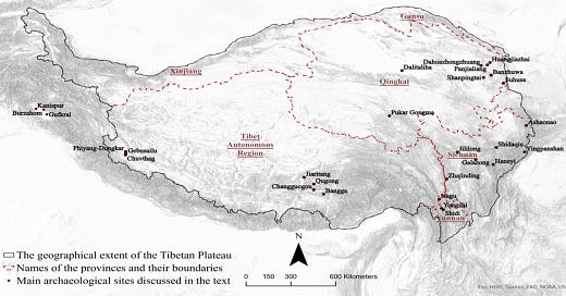
Spanning over 1 million square miles, the Tibetan Plateau stands as the world's highest landmass, boasting an average altitude of 14,000 feet. Despite its formidable environment, humans have inhabited this region since ancient times.
The Intersection of Farming and Herding: A Historical Overview
Farming and herding have been integral to the Tibetan Plateau's economy since time immemorial. Through intricate interactions and movements, farmers, agropastoralists, and herders have shaped the plateau's economic and cultural landscape.
Unlocking Ancient Connections: Geospatial Insights and Archaeological Evidence
A groundbreaking study1, conducted by researchers from Washington University in St. Louis and Sichuan University in China, delves into the origins of cultural interactions across the Tibetan Plateau. Published in Scientific Reports, the study sheds light on prehistoric mobility and subsistence strategies, dating back to the Bronze and Iron Ages.
Navigating the Terrain: Geospatial Modeling and Simulation
Employing advanced geospatial modeling, the researchers simulated optimal mobility pathways used by ancient farmers and herders. These simulations, based on land cover and environmental capacity, revealed recurring patterns that correlated with the geographic distribution of prehistoric sites.
Mapping Social Networks: Insights from Archaeological Findings
To understand the impact of mobility on social interaction, the research team compiled a comprehensive database of archaeological discoveries from Bronze and Iron Age sites across Tibet. By analyzing shared ceramic styles and technologies, they constructed a social network map, highlighting connections between distant communities.
Mobility as a Catalyst for Social Cohesion
The overlay of mobility maps with social networks unveiled a compelling correlation between subsistence-oriented routes and strong material culture ties. Dubbed "mobility highways," these pathways facilitated not only farming and herding practices but also the development of robust social relationships.
Unraveling East-West Disparities: Cultural Orientation and Mobility Patterns
While the study illuminated widespread connectivity across Tibet, it also uncovered disparities between the eastern and western regions. The western part, less aligned with mobility patterns, hints at an alternative cultural orientation toward Central Asia, mirroring findings from previous archaeological investigations.
A New Perspective on Ancient Social Dynamics
Lead author Xinzhou Chen underscores the study's significance in elucidating the formation of human social cohesion. By unraveling the intricate interplay between mobility, subsistence strategies, and cultural connections, the research offers fresh insights into the dynamics of ancient communities on the Tibetan Plateau.
Through a blend of cutting-edge geospatial analysis and meticulous archaeological inquiry, this study transcends disciplinary boundaries, offering a holistic understanding of prehistoric mobility and its enduring impact on human societies amidst the extreme terrain of Tibet.
Chen, X., Lü, H., Liu, X., & Frachetti, M. D. (2024). Geospatial modelling of farmer–herder interactions maps cultural geography of Bronze and Iron Age Tibet, 3600–2200 BP. Scientific Reports, 14(1). https://doi.org/10.1038/s41598-023-50556-9


